Monday, September 30, 2013

Enjoy the Mist on Yosemite's Signature Hike


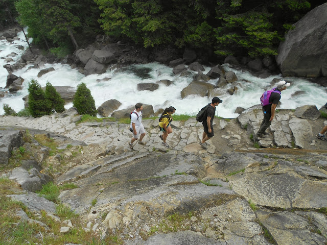
  The Mist Trail is Yosemite National Park's Signature hike.
It is best traversed in the spring, from the waterfalls are thundering.
At a three mile roundrip (and a 1,000-foot elevation gain), the hike to the lower of two large waterfalls, Vernal Falls, is moderately strenuous.


All of the first half of this hike is paved.
Begin the hike near Curry Village.
It's great scenery and at times, a wilderness feeling, along this sometimes crowded trail.


Shoes with good traction are a must here, as water does mist over the path in the section just below Vernal Falls.
Some take an umbrella, or a raincoat.


Others just strive to protect their camera.
The trail narrows to one-day travel during the final approach to the  Vernal Falls summit. From there, its cement and rock and a railing for a lookover. This is a great place for a picnic.


--If you continue on, it is another 2 miles to the top of Nevada Falls,plus another 900 feet in elevation. The second falls isn't as stunning as the first, but the crowds thin out on the later section.
Those who hike the backside of Half Dome also use this trail in the summer, when the cables are up.


From the Top of Yosemite Valley: America's Tallest Waterfall


                               Falls view from half-way up the trail
                                                                                    All photos by Ravell Call
                                                        
Why enjoy America's tallest waterfall, Yosemite Falls, only from the bottom?
 A 7.2-mile round-trip hike in California's Yosemite National Park, will take you 2,700-feet skyward for a bird's-eye view of the spectacular plunge, seventh tallest in the world.
Now this isn't a "walk in the park," it is classified as a "strenuous" hike by the National Park Service. It recommends having six to eight hours to complete the trek.
If there's one key word hikers will learn traveling this trail, it is "switchbacks," as there are more than 120 to negotiate.
"How many more are left?" is a common query overheard along the path. "Switchbacks galore" is how one hiker described the trail.
"Lots of switchbacks up the trail and it gets moderate crowds — like everything else in Yosemite? but worth it," Arthur Dugbee from Indianapolis wrote on Summitpost.org after his hike.

                                                      The Falls overlook.


A bronze model of the falls and switchbacks is located just north of the parking area for the Lower Yosemite Falls paved path. It is here where the best preview of what hikers undertake is to be found.
"Whew, what a set of stairs!" is how another hiker described it.
While scrutinizing that model, a middle-aged outdoorsman from Alaska walked by and offered a 10-minute recount of his experiences there the previous week. Even though he didn't make it to the top, because of snowy weather, he still thought it was a great experience.
He also cautioned that coming downhill isn't easy either, because of the loose gravel and dirt on the sometimes wet, rocky trail steps. That's why older hikers may want hiking poles for this expedition.
The Upper Falls Trail, one of the oldest in Yosemite, was constructed between 1873 and 1877. Superbly engineered, the trail is cut back in the mountain and offers plenty of comfortable margins from cliffs and drop-offs.


Shade dominates the first half of the trail. Some of the middle trail also goes downhill for a 600-yard stretch as it curves toward the falls. The middle section also includes chances to see rainbows and some misty but refreshing showers from the nearby falls, depending on the wind.
The trail begins about 0.3 of a mile northwest of Yosemite Lodge, near the "Camp 4" parking lot (formerly "Sunnyside), or shuttle-bus stop 7.
Even if you only go a mile up the trail, the Columbia Rock viewpoint offers panoramic looks at the valley. This is significant, because the lofty Glacier Point viewpoint is often not open well into May and this is a worthy alternative.
"Do not stray off the marked path, as you will find steep drops adjacent to the trail," the Park Service's trail guide warns.
Is that warning justified? Yes. Of the 13 recorded deaths along the Upper Falls Trail since 1927, all but one involved hikers taking shortcuts or scrambling off the marked trail. The other death was a 17-year-old in 1980 who was running down the trail out of control and somehow ended up falling 600 feet.
(One of the trail fatalities was Steven Leroy O'Neal from Salt Lake City, who scrambled off trail to his death on Feb. 23, 1980.)


Signs also warn of falling rocks along the trail. This too is justified, because one fateful day in November 1980, a slab of granite 200 feet high and 60 feet wide broke off above the central portion of the Upper Falls Trail, killing two hikers and injuring 20.

                                  The actual summit, to the west of the Falls.


Notwithstanding such tragedy, thousands safely hike this trail each year by using common sense and remaining on the path. Extra caution should be exercised on the trail where it is wet and slippery.


Hikers on top need to watch the trail signs and avoid the longer segment that continues north along Yosemite Creek into the backcountry. Swimming in the creek topside is also not advised.
Many large rocks offer rest along the mountain skyline. From there, the trail continues downward several hundred feet to a fenced off observation area. A narrow path cut in the rock, complete with a metal railing to hold on to, leads there.
The views are indeed stupendous from the overlook.

This trail is usually only open halfway up the mountain in the winter and spring is the best time to hike the falls, when the water flow is at its greatest. In late summer and fall, the falls may just be a trickle or even dry altogether.

For more information, go to: www.nps.gov/yose
(-Originally written by Lynn Arave in the Deseret News, June 18, 2009.)


Ascending Arizona's Dormant Stratovolcano: Mount Humphreys


                                                                                                                 All photos by Ravell Call


Hiking Humphreys Peak, the highest point in Arizona, is actually ascending the remains of a dormant stratovolcano that dominates the high desert landscape in the Flagstaff region.
At 12,633 feet above sea level, Humphreys is a nine-mile round-trip hike that climbs 3,200 feet from the Arizona Snowbowl ski resort's lower parking lot, in the Kachina Wilderness region of the Coconino National Forest.
The peak rises some 5,700 feet above Flagstaff, though Humphreys is not visible from all but a small slice of the southeastern part of town. That's because neighboring Agassiz Peak (elevation 12,356 feet) obscures Humphreys from the majority of Flagstaff.
Scaling Humphreys' upper reaches is a lot like hiking Mount St. Helen's in Washington; wooden poles mark the path through lots of loose volcanic rock.

"This is amazing that Arizona can have such a rugged mountain," Marilyn Sanders, another Calgary resident, said.
"I think it looks like you are on top of the world," said Phil Rosso of Calgary, Alberta, Canada, after reaching the Humphreys summit in late morning.
"The hike was OK, a little tricky at the top," Jackie Hester, from Carpinteria, Calif., said after reaching the Humphreys summit.
She was also impressed by the clear skies and no wind — a rarity on the usually blustery summit.
"Spectacular views, very windy," was what Mike Vuk recorded in the summit's log book.
"It's windy. I bet everyone writes that," Robert Conly wrote in the log.


"Praise God for his awesome creation," is what Keith Wegehaupt wrote in the summit log.
Roy Major from Tempe, Ariz., wrote that he had scattered his son's ashes on the peak in accordance with his last wishes.
Adam Schafer penned this: "Awesome hike. I am beat! Where's the hammock?"
Humphreys is best hiked in late summer or early fall (June to October), when there is no snow. The shortest starting point is the Snowbowl's lower parking lot, at 9,500 feet above sea level. The resort is about 14.5 miles from Flagstaff.
There is a restroom but no water available at the trailhead.

The current trail was built in 1984.
The U.S. Forest Service states that the hike is a strenuous one, with moderate to heavy use. The hike requires three hours to the summit along a steep path through "a thriving alpine forest streaked with huge rock slides and avalanche tracks hug the mountain's slopes."
The Forest Service report continues: "As the elevation increases, trail-side vegetation shows more and more evidence of the extreme harshness of this environment. Near tree line, what's left of the forest consists entirely of bristlecone pines bent and twisted by wind and frost. This hardy tree manages to live one of the longest lives on earth in one of the planet's most inhospitable environments.


The trail is well-marked in the early stages. After crossing a meadow under the ski lift, the trail goes through a dense forest with plenty of shade. However, after two miles, it crosses an elevation of 11,400 feet, just below the timber line.
"Above tree line, the only plants that can survive are small tundra shrubs and wildflowers that huddle for shelter among the rocks. Some are found nowhere else in the world. Overhead, above Arizona's highest ridge, white-throated swifts dive and flash like miniature fighter planes as they feed on nearly invisible insects borne on the wind."
No mechanized or motorized vehicles, including bicycles, are allowed along the trail. There is no hiking off-trail above the tree line or camping, in order to protect the San Francisco Peaks Groundsel, a plant found nowhere else in the world.
For this reason, it is also not legal to use the Snowbowl ski lift to hike Humphreys, since you have to go off trail.
Backcountry permits are required in the winter here.
Ski poles may be helpful for older hikers in the trail's upper reaches of loose rock and soil.


On top, there is a panoramic view that includes the distant Grand Canyon on a clear day. Many expanses containing volcanic cones are also readily visible. A circular pile of rocks has been built at the summit for a measure of protection against the usual winds there.
Hikers need to be cautious of incoming thunderstorms, especially in the afternoon, as lightning is the main hazard above 12,000 feet.
Humphreys is part of the San Francisco Mountains, the remains of a 15,000-foot volcano that existed here 200,000 or more years ago, until it exploded and/or collapsed. It is believed to have had a pyramid shape and looked a lot like Japan's Mount Fuji.
The huge volcano's cataclysm left the five major peaks visible on the mountainside today. These San Francisco Peaks are sacred to 13 Native American tribes in the region.
So great is Indian reverence for the peaks that some tribes recently took court action to block an attempt to use reclaimed water on the mountain to create snow for the Snowbowl resort. The Native Americans wanted pure water used on the sacred slopes.
The Hopi Indians called the mountains "Nuva'tuk-iya-ovi," or "place of high snows."
In contrast, early Spanish explorers called the San Francisco Mountains originally "Sierra Sin Agua," or "mountains without water," because of the absence of any rivers flowing off the mountains.
Humphreys was named after General Andrew A. Humphreys (1810-83), who was chief of the U.S. Corps of Engineers from 1866-79.
The wilderness around Humphreys is the only alpine tundra environment that Arizona has.
Eleven other states have high points that exceed Humphreys in height. Utah's Kings Peak, at 13,528 feet, is one of them. For overall difficulty of climb, the Highpointer's Club (America'sroof.com) ranks Humphreys as the 10th hardest, behind Colorado's Mount Elbert. Utah's Kings Peak is seventh toughest.

--If you go
To hike Humphreys Peak from Flagstaff, drive north on U.S. 180 for seven miles to Forest Road 516, the Snowbowl Road. Drive 7.4 miles on this paved road to the lower parking lot of the Snowbowl facility. The trailhead is located at the north end of the parking lot.
For more information, contact Peaks Ranger Station; 5075 N. Highway 89; Flagstaff, AZ 86004; or call 928-526-0866.

For additional information on hiking Humphreys, consult "Highpoints of the United States," by Don W. Holmes, or "Highpoint Adventures," by Charlie and Diane Winger.
(-Originally written by Lynn Arave in the Deseret News.)

Hiking Colorado's Highest Summit: Mount Elbert

                                                                                                                All photos by Ravell Call

Forget Longs Peak or even Pikes Peak: The lesser-known Mount Elbert is Colorado's highest point at 14,433 feet above sea level.
The second-highest point in the lower 48 states, behind California's Mount Whitney (14,494 feet), Elbert is a peak bagger's delight. It is as little as a 4.5-mile one-way hike, only climbs 4,358 feet from the trailhead and is scaled too in the winter by experienced mountaineers, because its gentle slopes moderate avalanche dangers.
Located in the Sawatch Range, about 10 miles southwest of Leadville, Elbert isn't as impressive looking from below as its nearest neighbor, Mount Massive (Colorado's second highest at 14,421). However, on top is one of Colorado's best panoramas, and unlike Pikes Peak or Longs Peak — both on the Front Range — there's far less trace of civilization nearby.


"Fourteeners" (14,000-foot or taller mountains) are common in the Centennial State. There are 53 Fourteeners in Colorado, none in Utah. (For comparison purposes, Utah's tallest summit, Kings Peak, is more than 900 feet shorter at 13,538.)
But despite the abundance of impressive peaks, "Wow" is still a common adjective heard among hikers who reach Elbert's summit.
Dozens of people a day reach the summit in the summer, with about half coming from the two longer routes: Black Cloud Trail (5.5 miles, one-way) or the South Trail (6.2 miles, one-way). There are also two other more obscure paths to the summit.
Ideal hiking time is June through the end of September. The only potentially disappointing factors in the hike would be stormy weather or getting "psyched-out" by the several false summits.

With the treeline in central Colorado in the 12,000-foot elevation range, surprisingly the first third of the hike up is through pine and aspen forest. The trail is well-defined, though one of the steepest sections before the summit does have an ample supply of loose rock — worse on the downhill return.
As with any high-altitude hike, carry plenty of liquid, have warm clothing on hand, beware of altitude sickness symptoms and watch the skies for potential lightning danger. In summer, it's a good rule to summit by noon to avoid storms.


• "This was our first Fourteener and a really great experience! . . . The aspen leaves were yellow, the sky was a dark blue and there was no snow or rain in the morning. Thanks to experienced hikers who gave us a lot of good tips for planning." — Tom Briscoe, Matt Briscoe, Michael Briscoe, Fort Collins, Colo.
Mount Elbert was named for Samuel Elbert, territorial governor of Colorado in 1873. It had other names, but Elbert stuck. A feud with lovers of nearby Mount Massive meant hikers used to stack rocks on that peak, hoping to elevate it above Elbert. Apparently, most of these efforts were abandoned when the U.S. Geological Survey declined to recognize any increase in height.
For part of the 19th Century, Pikes Peak was believed to be Colorado's highest and Elbert was undiscovered.
Unlike Kings Peak or Mount Whitney — totally covered with large slabs of rock on top — Elbert actually has a fair amount of true dirt on top. What rock is on the peak has been used to create a few rock wall shelters from the gusty winds that frequent Elbert.
On top is a truly panoramic, eye-candy view that could only be exceeded in an airplane.
Most hiking guides consider this a good day hike, with three hours up and two hours down as the norm on the south trail. Like Mount Whitney, this is one of those long walk hikes, with no special skills required.
Although you can drive to some other 14,000-foot peaks in Colorado (Pikes Peak and Mount Evans), this may be the easiest hikeable-only Fourteener in the country.
Consider this sampling of personal summit entries this past summer, taken from an on-line after-the-summit Web site, www.peakware.com/wsl/logs/elbert.htm:

                                                                                                                               Ravell Call Photo
• "First 14'er for me — I've lived in (Colorado) Springs for 7 months, so the altitude was not that bad . . . so I thought. Once Nicola and I got to the steep areas we could really feel the effects of it! She commented on how mountain area natives have genetically superior lungs. I definitely don't fall into that category. Great to get to the top, my legs are paying for it now . . . will go back to more 14'ers, I'm sure." — Shafinah Rosauro, Vallejo, Calif.
• "My Outward Bound group started the hike around midnight so that we were on the summit in our sleeping bags to watch the sunrise. It was incredible! I couldn't tell the difference between clouds and snow until the sun burned the clouds off!" — Connor Broaddus, Richmond, Va.
• "Lovely day. In Denver on business. Drove to Massive/Elbert trail head and slept in rental car in Halfmoon campground area. Left around 6 a.m. Passed a couple of groups and lone hiker on way up. Topped out at 8 a.m. Bomber day. Fantastic views. Tripped and scraped myself up jogging down. Wisdom: always wear some cheap gloves — the gloves at least saved the palms of my hands." — Jordan Clay, Bloomington, Ill.
• "Those false peaks are just that . . . false. Don't try to get down too quickly, and as always, take more water than you think you'll need." — Josh Richard, Greeneville, Tenn.
• "A straightforward climb of an easy, but steep, trail. Five and one-half hours up, four down. Elbert is amazingly un-rocky, even at the very top. . . .Truly amazing to stand on the highest point of land for 1,000 miles in any direction. My wife, my daughter, and my 15-year-old granddaughter, making her first 14'er climb, also made the climb. We were passed (twice) by a 54-year-old man who— ran — up and down the peak. My hat's off to him." Patrick L. Lilly, Cheyenne Canon, Colo.


• "We are amazing, we did it!! Party on top!" — Alex Rogers, Rochester, Minn.
• "I started out late (10 a.m.) and paid for it. I got to the tree line (12,200 ft.) about 12 and a storm was coming in. I decided to go up and got to about 12,800 and got hit by a thunder/hail storm and went back down to the tree line to wait out the storm. I waited for about three hours, freezing my butt off and watching people come down. I finally saw a break in the storm and took off about 3 p.m. I didn't see another person and had the summit to myself. I reached the summit about 4:30 to 4:45 and took off back down at 5 p.m. The views are beautiful. It was windy and cold. I should have taken a rest day and went early the next morning to avoid the storm, but I was impatient. It is a pretty easy trail all the way up." — Joe Buhler, West Jordan.
— To reach the North trailhead (10.075 elevation) from Leadville, go 3.5 miles on Highway 24 to Colorado-300. Turn right (west) on No. 300 and drive 0.7 miles. Turn left (south) on Colorado No. 11 and go on a dirt road almost 6.5 miles past the Halfmoon Creek Campground to the signed North Elbert trailhead. (Do not continue to the Mount Massive trailhead or you've gone too far.)
The dirt road has washboard sections but lacks potholes, and regular cars can handle the road at low speeds. Vault toilets (2) are available at the trailhead, but there is no water.
Nearest motels and services are in Leadville.
(-Story by Lynn Arave was originally in the Deseret News.)

                                                                    Mount Elbert

Utah's 'King' of Peaks


  Above: Top photograph shows the actual summit of Kings Peak. Lower picture highlights some of the rugged, steep cliffs around Kings Peak and looking into Henry's Fork Basin.


RISING royally some 80 miles due east of Salt Lake City is Utah’s king of Peaks – appropriately named Kings Peak.
Welcome to the roof of Utah, where rarified, thin air, with only 60 percent the oxygen content of sea level exists. 

This almost unearthly landscape is mostly devoid of trees and bushes, yet offers sweeping, open and telescopic views of wilderness areas from seemingly endless boulder fields.
This is an alpine eden, where naked rocks and jagged shapes rule and also  well above the mosquito and swamp level of the wet, grassy valleys below.


Above: The former metal plaque that used to sit on Kings Peak until it mysteriously disappeared in the early 21st Century.

Among high points of the 50 individual states, Utah's Kings Peak ranks sixth in total elevation. Best hiked in July through September, it is rated as a "Class 2" climb, according to Don W. Holmes, author of "Highpoints of the United States."
This means ascending Kings Peak requires "Rough cross country travel . . . boulder hopping and use of hands for balance." It is almost a 30-mile round-trip hike from the (Henry’s Fork) trailhead parking lot to Kings and back.

--Also, there's this legend I've heard about Sir Edmund 

Hillary, one of the first two men to conquer Mt. Everest in 

1953, that he also climbed Kings Peak.


This is true, but it was in the summer of 1978 when Sears and 

Kellwood (an outdoor equipment manufacturer), was testing 

camping gear in the Yellowstone drainage of the High Uintas.


Hillary, age 59 then, was said to have had little trouble hiking 

Kings Peak and the Uintas.

Hillary had also floated the Green River in Utah during 1969, 

as part of the centennial commemoration of John Wesley 

Powell's 1869 original exploration of the area. So, he spent  

time in the Beehive State, if only because the Kellwood 

company had an office in St. George, Utah.


(This is according to "Camping With Ed: From the Field Test 

Journals" book by

William N. Kelley, with a forward by Hillary himself.)

                      Above: Kings Peak as it appears looking north from near South Kings Peak.


 Above: The High Uintas view from atop Kings Peak, looking southward.


Not a legend though is that today's Kings Peak was undiscovered until the mid-1960s. Prior to satellite measurements, the U.S. Geological Survey pegged today's South Kings Peak as Utah's tallest. Any hikers going to Kings Peak prior to 1966 would have scaled the state's second-tallest peak instead.
Well above timber line, the Kings Peak terrain features endless rock slabs or boulder fields across the horizon. No motorized vehicles are allowed here. This is federally protected wilderness (although grandfathered sheep grazing rights still exist in the Henry’s Fork Valley below).

                         Kings Peak reflection from Henry's Fork Basin.

Kings Peak, almost 1.8 miles higher in elevation than Salt Lake's Temple Square, was named for Clarence King, director of the first U.S. Geological Survey team that came through Utah in 1867-71.
Ironically, King himself was never aware of Utah's tallest point, since it went undiscovered until 25 years ago. Initial measurements erroneously pegged South Kings Peak, near today's Kings Peak, as tallest.

  Above: Scott Wesemann scales the rock slide shortcut on the way to Kings Peak.


Each summer, thousands of hikers make the trek to “bag” Kings Peak, mostly in July through September. The most popular starting points are from Henrys Fork or China Meadows, but it's a strenuous 14-mile (one way) hike, usually best performed during a camping trip of three or more days.
The final half-mile (gaining 828 feet in altitude) from Andersons Pass is a scramble, requiring the use of handholds over loose rock slabs.

          Looking back at the south side of Kings Peak.

But today most hikers take the steep rockslide shortcut and climb up a chute of rocky debris almost 2,000 feet from the valley below to Andersons Pass.
Hearty snowshoers and cross county skiers sometimes reach Kings Peak even in winter.
 Above: Roger Arave and Scott Wesemann climb the rock slide shortcut out of Henry's Fork.


The dizzy view from the top of the rockslide shortcut, near Anderson's Pass/


 Above: Ravell Call in the rockslide. Some years there is still some snow in the rockslide in mid-summer.

(--Distilled from various Deseret News stories and hikes to Kings Peak, between 1990 and 2003.)

-Photos by Lynn Arave, Roger Arave and Ravell Call.


(